Whilst thinking about the concept of the Square Mile series, I came across the artist and photographer Ed Ruscha.
He has compiled a number of photographic series, including ‘Parking Lots’, shown below, which is a collection of 37 photographs depicting large scale parking lots from above.
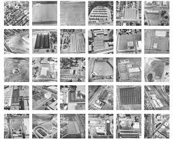
Although each parking lot is essentially providing the same service to consumers and is relatively mundane in appearance, each photograph is unique in the patterns and shapes that they form, and in some photographs depict large sporting arenas, including that of the Dodgers Baseball Stadium in Los Angeles.
From above, initially it can be difficult to tell what the photograph is of, until you zoom in and realise each small line is a vehicle.
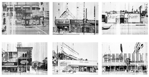
Another series which I enjoyed is ‘Every Building on the Sunset Strip’, taken in the 1960’s, which follows each side of the famous Hollywood road for a mile and a half, showing store fronts , restaurants and parking lots.
The series allows the viewer to walk down Sunset Boulevard in photographic form, from anywhere in the world, at any time, day or night, years before the invention of Google Maps and the like.
The above series is very similar in concept to the Square Mile assignment and my own project based around the de Havilland Heritage trail.
Each photograph on the trail follows on from the previous one in a map like format, and enables the viewer to see the area through the photographs as if they were there in real life.
